d
Points of Interest > Keating Channel
By the early 1890s, conditions in Ashbridge’s Bay marsh at the mouth of the Don had become unbearable: the stench of sewage, industrial, and animal wastes was a constant source of complaint for area residents, and provincial health authorities warned of the potential for a serious cholera outbreak. A series of lawsuits, combined with pressure from the province, finally compelled the City to act.
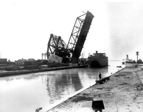
Drawbridge over the Don River, ca. 1915. City of Toronto Archives, Fonds 1244, Item 1482.
In the fall of 1892, Council approved an emergency relief plan prepared by City Engineer E.H. Keating. The plan called for the construction of a channel running east-west along the northern perimetre of the marsh, with openings into Toronto Harbour in the west and to Lake Ontario in the east to facilitate water circulation through the marsh. The Don would be diverted into the new east-west channel on a line running south of the existing improvements. The final product, completed in 1893, differed significantly from Keating’s proposal. “Keating’s channel” was dredged to a width of only ninety feet (rather than the three hundred feet proposed in his original plan). Coatsworth’s Cut was completed to specifications at the eastern end of Ashbridge’s Bay, but the Don was not diverted into Keating’s channel as proposed.
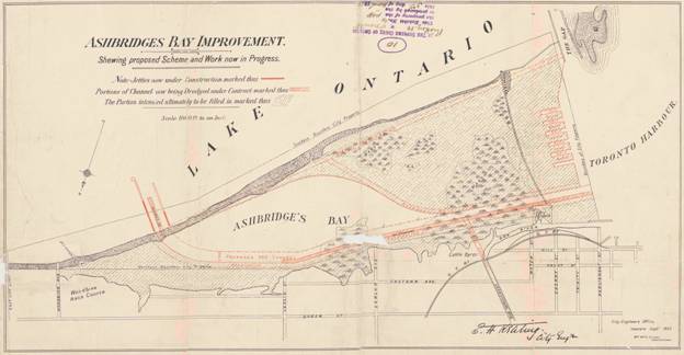
E.H. Keating, City Engineer, Ashbridge's Bay Improvement shewing proposed Scheme and Work now in Progress, Toronto: City Engineer’s Office, 1893, City of Toronto Archives, Series 725, File 7 (MT995).
Final adjustments to the mouth of the river occurred within the context of the Toronto Harbour Commission’s 1912 Waterfront Plan. The plan, conducted under the leadership of THC Chief Engineer E.L. Cousins, diverted the river southwest from the GTR bridge, then south to meet with a widened and reinforced Keating Channel before entering the harbour. Objections by British American Oil Company, whose property lay along the line of the proposed diversion, led to a final amendment: rather than curving through the BA Oil property, the river would continue straight south to connect at a right angle with Keating Channel—the same jarring alignment that persists today. The new Keating Channel—wider and slightly south of its previous alignment—was dredged in 1914; by the spring of 1915, the channel had been reinforced and the river diverted for the final time.
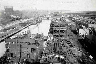
View looking east along the Keating Channel from the bascule bridge at Cherry Street, showing wooden-hulled cargo vessels under construction at the yard of the Toronto Shipbuilding Company, 19 October 1919. Toronto Port Authority Archives, PC 13/1, image 208.
Despite years of improvements to the Lower Don and the river mouth, ongoing problems with silt and debris accumulating at the mouth of the river have necessitated costly annual dredging. As the watershed became more urbanized in the 1940s and 50s, particularly with the construction of the Don Valley Parkway, larger quantities of silt and debris collected in the channel where flow levels are low. The problem persists today. In 2005, for example, the Toronto and Region Conservation Authority (TRCA) barged 35,000 cubic metres of silt from the Keating Channel to a dumping site at the Leslie Street Spit.

Silt from Don Valley moving through Eastern Gap after heavy rains, 14 September 1962. Keating Channel is in the top right corner of the image. Toronto Port Authority Archives, PC 14/6845.
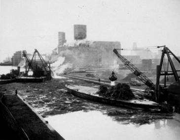
Dredging debris from Keating Channel, 13 April 1951. Toronto Port Authority Archives, PC 13/1, image 38.
In 2003, Waterfront Toronto announced a plan to naturalize the mouth of the Don as one of four priority projects for the Toronto waterfront. The Don Mouth Naturalization and Port Lands Flood Protection Project (found at http://www.trca.on.ca/), planned in partnership with the Toronto and Region Conservation Authority (TRCA), will “reestablish a natural, functioning wetland at the mouth of the Don River, while providing flood protection to approximately 230 hectares of land south and east of the existing Keating Channel” (TRCA, 2008). To date, the Environmental Assessment process has identified a "preferred option" based upon the winning design in an international design competition sponsored by Waterfront Toronto. The winning design team, headed by Michael Van Valkenburgh Associates Inc. (MVVA), has been chosen to lead the project vision. Meanwhile, to complete the Environmental Assessment, the TRCA is conducting a series of detailed studies of the area’s hydrology, together with alternatives for the management of sediment and contaminated soils. Completing the project will still be a challenge, however. Waterfront Toronto has stated in their Long-Range Plan that neither their original seed funding from the municipal, provincial and federal governments, nor returns on their subsequent business activities, will be sufficient to underwrite the naturalization and flood protection of the mouth of the Don, and new sources of funding will have to be identified for the project to be implemented.
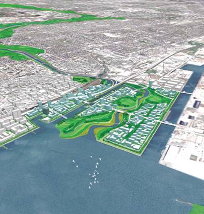
Preliminary design plan for the Don Mouth Naturalization Project, courtesy of Waterfront Toronto
Text: Jennifer Bonnell
Sources
By-law No. 4821 for the Straightening of the River Don, Appendix B, p.559, City of Toronto Council Minutes 1906.
D.R. Poulton & Associates Inc. Portlands Energy Centre, Archaeological Assessment for the Proposed Portlands Energy Centre, http://www.portlandsenergycentre.com/docs/nov2003/PEC_Archaeology-Final.pdf.
Sauriol, Charles. Remembering the Don: A Rare Record of Earlier Times within the Don RiverValley, Toronto: Consolidated Amethyst Communications, 1981.
The Task Force to Bring Back the Don. Bringing Back the Don. City of Toronto, 1991.
---. Don Mouth Revitalization Vision. http://www.toronto.ca/don/vision.htm
Toronto Harbour Commission Minutes, 1913, Toronto Port Authority Archives.
Toronto Waterfront Revitalization Task Force Report (Fung Report), March, 2000. http://www.toronto.ca/waterfront/fung_report.htm
